Precipitation Measuring Radar Operational in Space

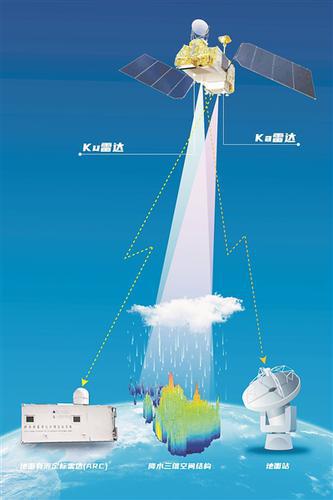
Diagram of Fengyun 3G in orbit. (PHOTO: 704 Institute of CASC's 9th Institute)
By FU Yifei & LIANG Yilian
On April 16, China launched the Fengyun-3G into space. Its main payload is China's first satellite-borne Ku and Ka Dual-frequency Precipitation Measurement Radar (PMR).
As part of China's meteorological and climate satellite system, this second-generation polar-orbiting environment satellite will provide crucial information on severe weather conditions like heavy rain that can lead to calamities like floods and landslides.
By August 29, the PMR had detected precipitation in the middle and low latitudes and captured the three-dimensional structure of the rainfall systems of Typhoon Mawar, and Typhoon Talim.
Pursuing new techniques for rainfall forecasting
China is located in the typhoon-active zone west of the North Pacific Ocean. Rainstorms and waterlogging have been the main natural disasters in some areas of the country.
In the past, due to technical limitations, it was difficult to obtain information on large-scale surface precipitation. In 1997, the U.S. and Japan jointly launched the Tropical Rainfall Measurement Mission (TRMM) satellite loaded with a precipitation radar, creating a precedent for deploying satellite-borne radars to detect precipitation.
In the early 21st century, China carried out preliminary research on such radars and realized that dual-frequency radars work better than the single-frequency radar used by the TRMM satellite.
"PMR can combine the advantages of high radar observation resolution and wide satellite observation range," Jiang Baisen, CASC microwave remote sensing technology research director, introduced that the Ku-band is conducive to the detection of strong precipitation, Ka-band is conducive to the detection of weak precipitation, and the synchronous work of the two can expand the detection ability of precipitation, even if it is 0.2 mm drizzle per hour, it can also accurately perceive.
Also, dual-frequency monitoring can distinguish rain, snow, hail, and other states, and detect liquid and solid changes in the precipitation process, which is very important in meteorological applications.
Overcoming challenges
However, the development of China's first satellite-borne precipitation measuring radar had to overcome many challenges. It was difficult to design, process and manufacture, the Chief Designer Yang Runfeng said.
In July 2010, Yang and his colleagues took the prototype to Sichuan province in southwest China to test it. It was summer and the weather was hot and humid while mosquitoes raged in the fields. The team bore the discomfort stoically and in September of that year, the test was initially completed.
After more than two months of flying tests, the research team finally obtained the required data, laying the foundation for subsequent engineering work.
Compared with ground-based radars, spaceborne radars face additional problems, such as surface echoes that interfere with detection.
The team carried out a lot of innovative research using electromagnetic wave radiation to suppress interference.
While the radar is functioning stably, the work of the developers is not over by a long chalk. They are now seeking to develop other precipitation-measuring radars in space, especially the next generation of such radars.
Meteorological work is closely related to life safety, production and development, and the ecological environment, and it is a major thing that concerns the happiness and well-being of the people, said Yu Yong, director of 704 Institute of the China Aerospace Science and Technology Corporation.


